
Urban Heat Islands
Urban Heat Island Effect
An urban heat island refers to the fact that urban areas are generally hotter than their rural counterparts. The difference in temperature between urban and rural areas has to do with how well each environment holds and absorbs heat. Rural areas have a lot more green space and canopy cover from trees, while urban areas have a lot more pavement from streets, parking lots, sidewalks, and other hard surfaces like buildings.
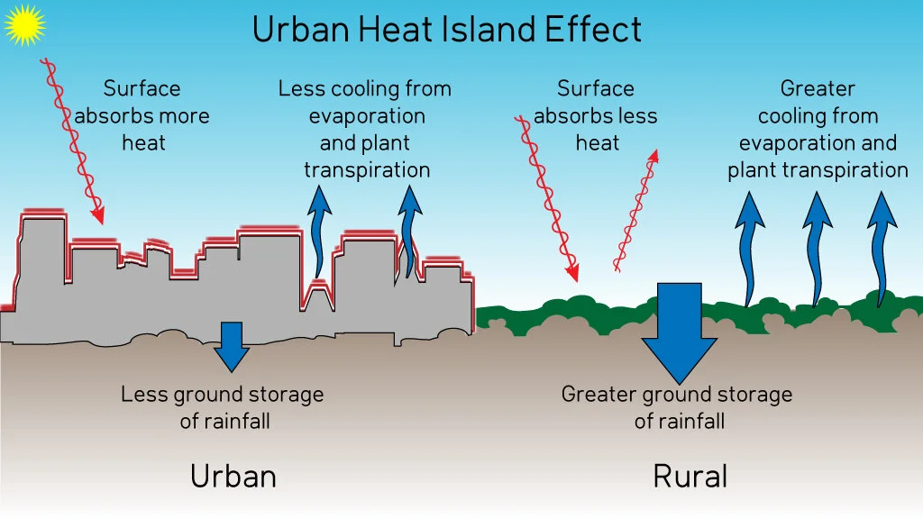
Image from Skeptical Science
The surfaces found in cities are usually made of asphalt, cement, brick, steel, and glass. Dark surfaces such as asphalt, steel, and brick are particularly good at converting light energy into heat, which can then heat up a city significantly. Dark colored asphalt absorbs anywhere from 80% - 95% of the sun’s rays. Whereas rural areas have a lot more shade from canopy cover and the significant ground cover of grass and plants don’t hold in heat from the sun, instead they transpire and actually help to cool their surroundings.
Vivek Shandas, a professor of urban studies and planning at Portland State University in Oregon, studies the urban heat island effect nationwide with a group of citizen science volunteers. He’s found that six things affect urban heat. They are the volume of the tree canopy, the height of the tree canopy, and the ground level vegetation; plus the volume of buildings, the difference in building heights, and the coloring of the buildings.
The volume of buildings can have both a negative and positive effect. Taller buildings cast shade which helps lower afternoon temperatures, while areas with only short buildings (like in the suburbs) can raise the temperature significantly in the afternoon. Additionally, Shandas found that an area with buildings of varying heights increases air flow, which helps cool things off. Ultimately, reducing the urban heat island effect requires a number of different techniques that incorporate a variety of building materials, green space and canopy cover, and thoughtfully planned neighborhoods.
Why is heat a problem?
Heat is the number one weather related cause of death, causing more deaths each year than floods, tornadoes, or hurricanes. Extreme Heat Resilience Alliance’s mission is to draw attention to heat as a public health crisis, particularly as extreme heat increases in severity and frequency across the country due to climate change.
In 1995, Chicago experienced a heat wave that led to hundreds of deaths over the course of five days. The city responded by strengthening and updating its emergency heat response system. While this has helped Chicago cope with heat waves, not all communities are alike. For instance, in New York City extreme heat is only getting worse, but roughly 700,000 people do not have air conditioning in their homes. Extreme heat also disproportionately affects low-income communities, people of color, and the elderly.
Underserved communities are less likely to have air conditioning or to be able to afford high utility bills, while these same communities are also more likely to suffer from the urban heat island effect. Multiple studies have linked low-income and majority minority neighborhoods with the largest urban heat island effects.
Researchers at UC Berkeley used satellite imagery to find neighborhoods across the US with few trees and a lot of heat-absorbing impervious surfaces. They then paired this information with US census data from 2000 and found that black people were 52% more likely than white people to live in urban heat islands. To further understand these large discrepancies, researchers have turned to historical practices, such as redlining.
The federal government used redlining to rate the riskiness of investing in certain neighborhoods according to four different grades - “best,” “still desirable,” “declining,” or “hazardous.” Race played a significant role as black or immigrant neighborhoods were defined as hazardous (and thus redlined), preventing people who lived in these communities from being able to receive federally backed mortgages or other lines of credit. We know now that access to this type of credit helps people develop wealth, particularly intergenerational wealth, thus leaving many of these neighborhoods and the people who live in them poorer than their non-redlined counterparts.
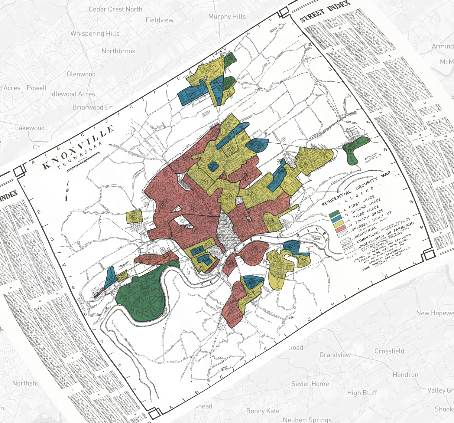
Image from the Mapping Inequality Project
Researcher’s from Richmond, VA and Portland, OR teamed up to study how redlining ties into how certain neighborhoods experience heat. They found that formerly redlined neighborhoods are on average 5 degrees hotter during the summer than the neighborhoods once favored for housing loans. These neighborhoods remain lower income and more likely to have black or hispanic residents. They also consistently have far fewer parks and trees and much more paved surface.
Ultimately, extreme heat is felt inequitably across the US and is exacerbated by the urban heat island effect. This is simply one of the ways that the climate crisis is disproportionately affecting lower income communities - as our world continues to warm these neighborhoods will feel fiercer and more frequent effects of extreme heat. Fortunately, there are solutions to these problems, and many cities are trying to mitigate urban heat and address these inequities.
Heat Island Solutions
There are many potential solutions to the urban heat island effect that incorporate green, sustainable solutions and thoughtful urban planning. One obvious solution is increasing green space and canopy cover city wide, but particularly in areas devoid of such things. Many cities have urban forestry divisions that specifically focus on planting more trees and caring for the ones the city already has.

Image from National Apartment Association
Another way to increase green space is to increase green roofs in a neighborhood, which are roofs that are partially or completely covered with vegetation. Communities can also focus on increasing the number of community gardens or parks in their areas, which have multiple health and environmental benefits, in addition to heat reducing qualities. These solutions not only increase green space, but reduce the amount of visible heat absorbing surfaces in a city.

Image from Los Angeles Bureau of Streets
City officials in Los Angeles have taken it upon themselves to actually lighten the color of some of the city streets with a reflective gray coating which will reduce roadway temperatures by up to 15 degrees. Another way to reduce the heat effect of streets and sidewalks is by installing permeable pavement throughout a city, instead of the traditionally used impervious asphalt and concrete. Permeable surfaces allow water to flow through them, which helps to cool the surfaces through evaporation and transpiration. They also have the added benefit of filtering our stormwater of pollutants that are traditionally picked up off our streets!
Efforts to mitigate heat risk ultimately need to be cognizant of the disparities felt across communities and need to be designed thoughtfully to address the historical inequities that have left poor and minority communities more vulnerable to heat in the first place. Thoughtful city planning and heat reduction strategies will take into account this narrative and focus efforts that include building and zoning ordinances, initiatives that increase green space and lightening heat absorbing surfaces in these communities. It’s also important to keep in mind that these initiatives will likely accelerate gentrification, so our cities need to ensure that residents in these areas have the resources they need to be able to stay.
Relevance to Knoxville
We’re fortunate in Knoxville to have such a lush and green landscape throughout most of the community, but some of our neighborhoods underwent greater development, and thus have less green space and canopy cover. Downtown is the most obvious example, but North Knoxville and Lonsdale are two communities that also have less tree cover.

Map of Knoxville displaying the city's canopy cover assessment, which shows Lonsdale and North Knoxville as having lower canopy coverage than other parts of the city.
Historically, these areas were graded as “hazardous” and “definitely declining.” While there was a small black population living in these neighborhoods, the designation more likely reflected the fact that this was largely an industrial area filled with lower-income families and individuals. The research from Jeremy Hoffman, Vivek Shandas, and Nicholas Pendleton that shows the relationship between urban heat islands and historical redlining, includes data from Knoxville showing that it is roughly 3 degrees Celsius warmer in historically redlined communities.
Luckily, we have many people hard at work in our community whose efforts are directly impacting our urban green spaces and canopy cover. Trees Knoxville, Keep Knoxville Beautiful, and the City of Knoxville Urban Forestry are just a few organizations whose mission directly impacts green space throughout our city. Trees Knoxville is conducting a new study of our urban tree canopy to capture the efforts that have been done since the last study and to see where we still need to improve.
We, as individuals, can also get involved by increasing vegetation in our own yards, by organizing a tree planting or community garden in our neighborhoods, and by petitioning the city to work on reducing the urban heat effect where we live.